restoration

Supporting Local Rural Economies while Improving Forest Health

This blog post was written with support from Amie Anderton (Intermountain Region), Lindsay Buchanan (Washington Office), and Teresa McClung (Pacific Southwest Region).

Calaveras County, nestled in the Gold Country and High Sierra regions of California, has a long and storied past.

It is the setting for Mark Twain’s famous short story, “The Celebrated Jumping Frog of Calaveras County,” published in 1865. However, this rural county and the neighboring Amador County have faced some more recent tough times.

Conserving Monarch Butterflies and their Habitats

With more than 80 percent of the world’s flowering plants relying on pollinators, their importance to natural ecosystems and agriculture cannot be overstated. However, populations of pollinators, including bird, bat, butterfly, beetle and bee species, have been declining around the world. Recognizing the importance of pollinators, Secretary Tom Vilsack of the U.S. Department of Agriculture has proclaimed June 15 to 21, 2015 as National Pollinator Week.

To celebrate Pollinator Week, we are sharing some of the Forest Service’s work to conserve one iconic pollinator species and its habitat – the Monarch butterfly. Monarch butterflies complete incredible migrations of hundreds to thousands of miles each year across North America. Along their migratory paths, Monarchs rely on habitats that contain milkweed species, which is the only plant that they lay their eggs on. Monarch caterpillars feed exclusively on milkweed, which contains chemical compounds that make them poisonous to potential predators.

For the Love of Trails and Trout

This post was submitted on behalf of the Pisgah Ranger District recreation staff and fire crew - Paul Ross, Forest Service Office of Communication

Accessed by the Blue Ridge Parkway and surrounded by the Black Balsam Mountains, the Sam Knob Project is located in one of the most scenic and highly visited portions of the Pisgah Ranger District. As we celebrate National Trails Day and National Fishing and Boating Week, we are highlighting this location as a showcase of how recreational trail design can protect critical fish and wildlife habitat and enhance user experiences.

Managing for Wildfires Every Single Day of the Year

On June 9, 2012, a lightning strike sparked a wildfire in the mountains west of Fort Collins, Colorado, burning into the Roosevelt National Forest. The High Park fire burned over 87,000 acres and remains the third largest fire in recorded Colorado history, with more than 250 homes destroyed.

Matt Champa, assistant prescribed fire specialist with the Canyon Lakes Ranger District of the Arapaho and Roosevelt National Forests, remembers clearly the two and a half weeks the High Park Fire burned. Matt was among the individuals actively working on the ground to suppress and contain the fire; at its height, more than 2,000 people were involved in the suppression effort.

Sustainable Land Management can Provide Building Materials for Post-Disaster Recovery

The U.S. Geological Survey estimates that several million earthquakes occur in the world each year. Some, such as the devastating earthquake in Nepal and the series of earthquakes that destroyed infrastructure, homes and communities in Christchurch, New Zealand in 2011, capture global attention.

After natural disasters such as these, rebuilding a city needs to be efficient and cost-effective, with an eye towards resilience in the face of future disasters. Engineered wood building systems like glulam and cross laminated timber, also known as CLT, are well suited to meet these needs as they are often prefabricated offsite and can be quickly installed. That helps communities bounce back from disaster in a shorter time frame while minimizing waste. Furthermore, just as trees flex in high winds, timber structures flex in earthquakes, placing wood construction systems at the forefront of seismic design for resilience.

Much Ado about Fisher

Located at the base of the Ashland Creek Watershed, the city of Ashland, Oregon, is home to nearly 21,000 people and a bustling tourist industry that revolves around world-class theatre experiences. Rogue Valley residents and tourists actively and passionately recreate in the Ashland municipal watershed, of which the upper portion is located primarily on the Rogue River-Siskiyou National Forest.

Like many areas in Southwest Oregon, a history of fire suppression has dramatically changed the way forests could potentially respond to fires. Stands once considered to be fire-adapted and fire-resilient have become densely overgrown. As a result of this fuels buildup, a high-intensity fire could result in the loss of the watershed’s largest trees, which help maintain soil stability and clean drinking water, and provide habitat for a diverse range of wildlife species.

Southwestern Crown Collaborative Focuses on Monitoring and Learning to Accomplish Restoration Goals

This post was written by Emily Olsen, Conservation Connect Associate at the National Forest Foundation (NFF). As the U.S. Forest Service’s non-profit partner, the NFF brings people together to restore and enhance our National Forests and Grasslands.

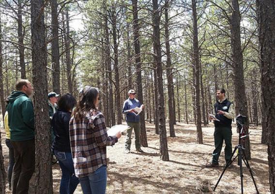
Situated among ponderosa pine, Douglas fir, and other endemic tree species, Montana’s Lubrecht Experimental Forest lends itself to learning and adaptation. In March, the Experimental Forest was a seemingly perfect place to discuss restoration goals during the annual Southwestern Crown Collaborative Adaptive Management Workshop.

Here at the National Forest Foundation, we’re feeling refreshed after the workshop. Participants from the Forest Service, local communities, conservation, and academia came together to discuss what the Southwestern Crown Collaborative has learned from wildlife, aquatic, socioeconomic, and forest vegetation monitoring over the past year. But the discussions didn’t stop there. Participants also deliberated opportunities for monitoring information to inform and influence public lands management across the local landscape.

Forest Service Exceeds Ecological Restoration Goals

I am proud to announce that we exceeded our ecological restoration goals for Fiscal Year 2014. This was no small feat.

A lot of great people across the U.S. Forest Service worked hard to make it a reality. We did substantial homework and planning, and then based on that we made strategic investments across all agency programs to help us create resilient forests, grasslands and watersheds while sustaining communities. This work reduced the wildland fire threats to communities and firefighters and minimized the risk of forest pests and climate change, while supporting American jobs and rural economies. That is a fantastic combination.

USDA is Acting on Climate and We Have a Plan

We know that there are climate change risks and vulnerabilities facing agriculture that have significant implications not just for farmers, ranchers, and forest landowners, but for all Americans and the world. That’s why we are working on measures to reduce greenhouse gas emissions and prepare for climate change impacts such as flooding, sea level rise, severe weather and temperature extremes.

Today’s release of the USDA Sustainability Plans and Climate Change Adaptation Plans coincide with the fifth anniversary of President Obama’s 2009 Executive Order on Environmental, Energy and Economic Performance, which set aggressive energy, climate and environmental targets for agencies, and detail how USDA’s actions have already contributed to reducing the Federal Government’s greenhouse gas emissions by more than 17 percent since 2008 – the equivalent of permanently taking 1.8 million cars off the road.

Conservation Groups, Farmers Protect & Restore Precious Puget Sound Estuary

When many people think of Washington State, they imagine rain, coffee and apples. My view is much more complex and nuanced, thanks to our team at NRCS who showed me diverse agricultural landscapes, including the state’s major estuary - Puget Sound.

During my visit, I was greeted by an idyllic landscape steeped in history. Early settlers to the Puget Sound area converted marshlands into pastures and hayfields. We visited one such area now known as Klingel Wetlands, where levee systems were installed in the 1890s and 1950s to prevent flooding.