This post is part of the Science Tuesday feature series on the USDA blog. Check back each week as we showcase stories and news from USDA’s rich science and research portfolio.
If you think the local weather forecaster has trouble predicting if it will rain tomorrow, imagine how hard it is to forecast crop production world-wide.
If there is too little rain in Brazil in August, it could delay planting of the country’s summer maize crop and subsequently diminish that harvest. If the decrease is big enough, it could possibly have implications for international commodity prices and might even impact global food security. This in turn can translate into the need for policy makers to respond to economic and trade issues and problems in countries where food insecurity is a persistent threat.
So the more precisely crop production and conditions can be monitored within the growing season at scales from local to regional to global, the more accurate harvest forecasts can be. And early but accurate harvest predictions give policymakers more lead time in which to respond.
It all comes back to scientists developing better ways to monitor and analyze conditions that affect crops and how crops are responding, particularly the four major staples--wheat, maize, rice, and soybeans.
So recently, USDA’s Agricultural Research Service (ARS) hosted two international scientific communities: GEOGLAM (Group on Earth Observations (GEO) Global Agricultural Monitoring Initiative) and AgMIP (Agricultural Model Intercomparison and Improvement Project) -- leaders in different aspects of crop monitoring to see what collaborations might be conjured.
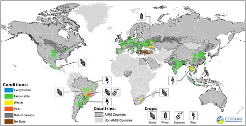
GEOGLAM focuses on monitoring seasonal agricultural production at the national, regional and global scales. It was launched in 2011 by the Group of Twenty (G20) Agriculture Ministers in response to calls for improved agricultural information to help stabilize international markets.
AgMIP makes regional and global assessments and long-term forecasts on how climate changes will impact crop production and the economic consequences.
ARS scientists have long been leaders in developing models that integrate factors into more precise reflections of crop-environment interaction. They have been providing research to help both programs and saw bringing them together as a natural next step.
Nearly 70 scientists, analysts and policymakers from 10 countries met in person or virtually for the two-day workshop.
“As a world, our food production system is already stressed to meet today’s demands. The future is going to mean challenges to provide for a growing population while adapting to a changing climate. Farmers need to know if their current agricultural systems will continue to produce the yields of today. Policymakers need to understand where food prices and availability will change. International organizations need to identify which regions will be the most vulnerable to food insecurity,” said ARS research ecologist Debra Peters who is serving as senior advisor for earth observations in the Office of the Chief Scientist, USDA, and was one of the meeting’s organizers along with Chris Justice of the University of Maryland and Cynthia Rosenzweig of NASA.
“Better agricultural monitoring and forecasts can help with these challenges and it’s a problem that scientists have been endeavoring to solve,” she added.

