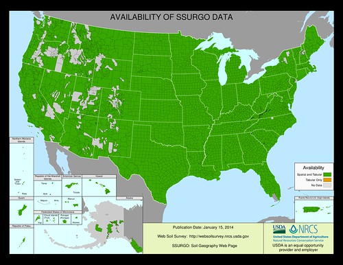
Soil scientists from across the southeastern region of the U.S. came together recently to celebrate the completion of Georgia’s soil survey. With this mapping complete, very few areas of the nation’s soils in the 48 contiguous states are not recorded.
USDA’s Natural Resources Conservation Service (NRCS) mapped soils information for Georgia’s 159 counties. The map data can be accessed online through NRCS’ Web Soil Survey.
Soil surveys involve studying the nature and properties of soils, mapping their location on the landscape and interpreting their unique sets of characteristics. The information found in these soil surveys was used by producers to better understand their soils, and how best to use and protect them.
“I remember some of my earliest mentors teaching me the importance of why the soil survey was the foundation for our conservation planning. I knew from then on, that this work was creating a vital tool for our conservation toolbox,” said NRCS State Conservationist for Georgia, Terrance O. Rudolph.
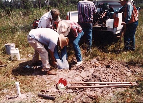
Over 200 soil scientists from many different organizations (federal, state, local agencies, as well as private entities and institutions) helped surveyed Georgia’s soils – work that involved observing, examining, studying, sampling, analyzing, classifying and naming the soils.
The first soil series established in Georgia -- named Tifton, Grady, and Chastain -- were from the initial soil survey of Grady County, conducted in 1909 by Hugh Hammond Bennett. Bennett, who went on to become the first Chief of what is now known as the NRCS (previously the Soil Conservation Service until 1994), worked on three of Georgia’s earliest soil surveys.
“An understanding of soils, the similarities and differences they exhibit, how they function, and how they respond to management is fundamental to much of the work we do,” said Georgia’s newly retired State Soil Scientist, Steve Lawrence.
While technology has changed the way soil surveys are conducted and used, they continue to contribute to productive agricultural lands across Georgia. The surveys provide critical information to other industries as well. Engineers in the construction industry consult the surveys for soil related considerations that may affect their projects before building site plans, whether they are residential, commercial or industrial in nature.
Utilization of new technologies will help with the next phase of Georgia soil surveys as we strive to help Georgia’s farmers, timber producers, and other industries become even more efficient and competitive on a global scale.
For more information on the history of Georgia’s soil survey visit: http://tinyurl.com/ofqdtwr.
The United Nations has designated 2015 as the International Year of Soils.