

On July 11, USDA’s World Agricultural Outlook Board cut the estimate for the 2012 U.S. corn crop by 1.82 billion bushels to “reflect expected impacts of persistent and extreme June and early-July dryness and heat across the central and eastern Corn Belt.” The 12% cut, which left the projected U.S. corn production at 12.97 billion bushels, is a direct result of the nation’s worst drought in a generation—since 1988. Yesterday, Agriculture Secretary Tom Vilsack also announced that more than 1,000 counties across in 26 states would be designated as disaster areas due to the worsening drought.
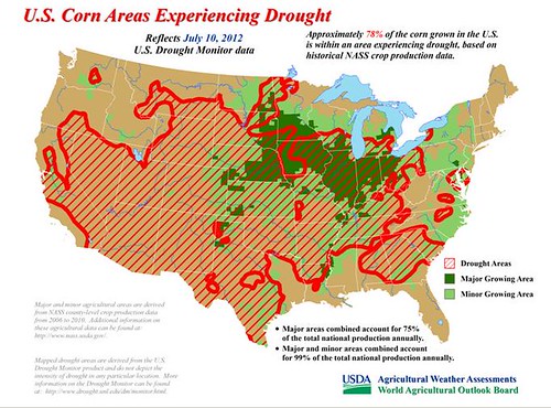
According to the July 10 U.S. Drought Monitor, 78% of the U.S. corn was within an area experiencing drought. Drought-free sections of the Midwest are currently restricted to parts of western Iowa and the northern tier of the Corn Belt.
During the next several days, a deep pool of atmospheric moisture over the southeastern U.S. will continue to focus drought-easing rainfall in that part of the country. Additional rainfall totals of two to four inches can be expected from the western Gulf Coast region into the Tennessee Valley. However, very little rain is forecast to spread north of the Ohio River, which will continue leave much of the Corn Belt in desperate need of moisture. Some late-week rain will occur across the upper Midwest, although totals will be generally less than an inch. During the next several days, high temperatures above 90°F will be common across the Midwest, and readings may approach 100°F in the southern Corn Belt.
For more USDA weather and climate information, visit our weather and climate page.