By Phil Sammon, Forest Service
Hindsight always proves to be most clear the farther you get from an event. The myths and legends of the event and the anecdotal side stories fade with time when held against the truths of the event or situation. Similarly, the projections and visions of the future impacts of the event can be quite different than what is first conjectured immediately afterward.
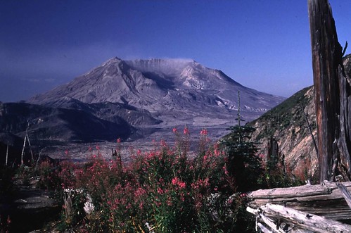
As we observe the 30th anniversary of the Mount St. Helens eruption, we can stand back and marvel at the ability of the natural resources to not only bounce back, but to flourish and astound us in its ability to literally rise up from the ashes of complete destruction. The evidence, including historic photos, data, and first-person accounts, are displayed on the Mount St. Helens National Volcanic Monument website, hosted by the US Forest Service. Beyond the science, the research, and the analytics of it all, stands the majestic Mount St. Helens as a tribute to the resilience and restorative power of the natural resources the agency manages.
The actual day of the eruption, Sunday May 18, started out bright, clear, and with no warnings or signs of the impending disaster that loomed just a mile below the volcano’s dome. Having spent Saturday night on duty at an observation post about 6 miles both of the volcano, US Geologic Survey volcanologist David A. Johnston radioed in laser-beam measurements he had made earlier that morning. The status of the measured activity showed no change from the pattern of the preceding month. About 20 seconds after 8:32 a.m. PDT, the bulged, unstable north flank of Mount St. Helens suddenly began to collapse, triggering a rapid and tragic chain of events that resulted in the now-famous widespread devastation. When the rumblings and upheaval diminished to a point where such details could be assessed, 57 people, including volcanologist David Johnston, had died.
The assessment also showed that 250 homes, 47 bridges, 15 miles of railways, and 185 miles of highway had also been destroyed. The eruption caused a massive debris avalanche, reducing the elevation of the mountain's summit from 9,677 ft to 8,365 ft (more than 1300 feet), and replacing it with a 1 mile wide horseshoe-shaped crater. The debris avalanche contained up to 0.7 cubic miles in volume. To put that into perspective, the debris avalanche from the eruption would completely fill all 32 NFL stadiums in the country 31 times.
In 1982, President Ronald Reagan and the U.S. Congress established the Mount St. Helens National Volcanic Monument, a 110,000-acre area around the mountain and within the Gifford Pinchot National Forest. The Johnston Ridge Observatory there is named in honor of David A. Johnston.
If you have the opportunity to spend any length of time on or around the Monument, you will be struck by the breathtaking panoramas and landscapes of the area. If you have the occasion to hike or camp there, you will only be more and more inspired by the ability of the natural resources to rebound: plants of all shapes and sizes are flourishing; wildlife has returned to many parts of the area; lodge pole pines are once again reaching toward the skies that 30 years ago were blackened out by the heavy plums of ash, smoke, and debris exploding onto the eastern Washington sky.