How many times have you been out for a weekend drive or on a trip and decided to visit a national forest or grassland only to discover that you have no idea how to get to the areas where you can have the most fun?
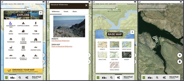
Well, problem solved—and just in time for National Great Outdoors Month! The USDA Forest Service has launched a free mobile app version of its very popular online visitor’s map called, simply, Visitor Map.
And for people like me, someone who depends on a mobile device almost like a sensory member of my body, it’s a game changer. Because if you’re like me, and I’m pretty sure a lot of you are, you’ve missed—way too many times—amazing things.
Those amazing things include challenging and exciting hiking and biking areas that “nobody” knows about, majestic views that will take your breath away, or soothing streams and impressive roaring rivers. Yet you have missed these amazing places because you didn’t have a map or a tour book or you couldn’t find a Forest Service Visitor Center.
This new mobile app fixes that, and, best of all, it’s incredibly user friendly. For instance, on the opening screen there’s an icon to the “explore” page where you’ll find about 15 different options for your outdoor adventure. Choices include everything from handicapped-accessible areas to the best spots to go dirt biking, fishing, camping or picnicking.
For those of us who plan ahead, there’s a helpful “search” icon that will allow you to find a forest or grassland near where you live or where you’re planning to travel. You can search by state or forest name. You can even easily share your location with family and friends using the “share” capabilities for email, Facebook and Twitter.
The app is literally a one-stop shop for all things wilderness. It includes a useful “tools” section that allows you to open base maps of forests and grasslands—options include satellite views or topography. You can also generate a map for your device to take on the road with you. The tools icon also has a legend that lets you know what roads are paved or closed and even if a trail for hiking is fully developed.
And if you’re curious about the latest in the Forest Service, the app will link directly to the agency’s website where you can read our latest feature stories or find out more about one of our program areas.
What are you waiting for? Summer is calling, so download the new app before you hit the road. The app is available through both Apple App Store and Google Play.


