The 2012 summer crop season is quickly winding down. By mid-September, more than three-quarters (76%) of the U.S. corn was fully mature and well over half (57%) of the soybeans were dropping leaves, according to USDA's National Agricultural Statistics Service. More than one-quarter (26%) of the corn had already been harvested by September 16, a record-setting pace. As the growing season comes to an end, corn and soybean conditions (currently 50% and 36% very poor to poor, respectively) remain comparable to those observed during the 1988 drought.
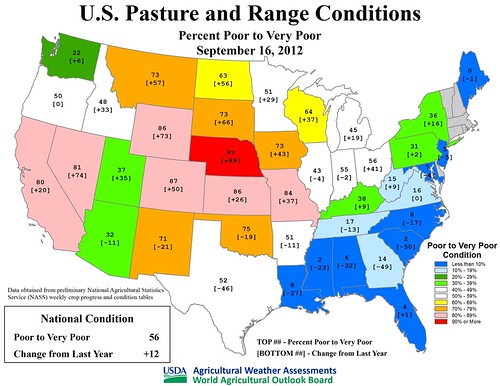
During the autumn of 2012, focus will shift to winter grains, pastures, and rangeland. U.S. rangeland and pastures, following five consecutive weeks at a record-high 59% very poor to poor from August 5 to September 2, have exhibited some slight overall improvement. Still, well over half (56%) of the rangeland and pastures were rated very poor to poor on September 16, despite substantial recent improvement in parts of the Mid-South, Lower Midwest, and Southwest. Currently, rangeland and pastures are at least half very poor to poor in 20 states, and at least two-thirds are very poor to poor in a dozen states. At the top of the list is Nebraska (97% very poor to poor), closely followed by Colorado (87%), Kansas (86%), and Wyoming (86%). In stark contrast, at least half of the pastures are rated good to excellent in every Gulf and Atlantic coastal state from Louisiana to Maryland.
Across the Plains and Northwest, ongoing or developing drought is also affecting early-season winter wheat planting. On September 16, wheat planting was at least 10 percentage points behind the five-year average pace in Colorado, Idaho, Nebraska, and South Dakota, reflective of drought-induced seeding delays.
Weather Outlook: During the next five days, most of the U.S. will experience a dry weather pattern. Significant shower activity will be mostly confined to the Great Lakes States, where some locations may receive one to two inches of rain. Temperatures will be mostly below normal across the eastern half of the U.S. and above normal in the West. Occasional frost can be expected in the Upper Midwest, especially on September 23-24. The Plains will experience dry weather and rapid temperature fluctuations. Looking ahead to next week, continuing warmth in the West will contrast with cool conditions in the East. Near- to below-normal precipitation will dominate the U.S., with significant rainfall expected to be mostly confined to Florida's peninsula, the lower Great Lakes region, and the Northeast.
Help those impacted by the drought through our Drought Code Sprint. Submit your apps by October 5!


