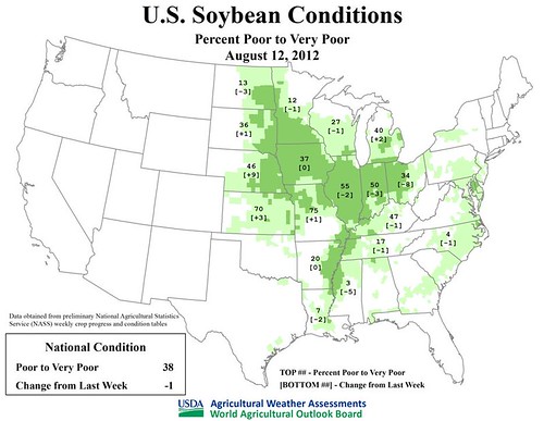
Cooler weather and recent rain showers have largely stabilized crop conditions in the Midwest. Rainfall has been heaviest in the eastern Corn Belt, including Michigan and Ohio, although nearly all of the Midwest has received some precipitation. Still, U.S. corn and soybean conditions remain at levels unseen since the Drought of 1988, according to USDA/NASS. During the week ending August 12, corn rated very poor to poor rose slightly to 51%, just two percentage points shy of the August 1988 peak. Soybeans rated very poor to poor reached a record-high 39% last week, but improved one percentage point during the week ending August 12.
This year’s U.S. corn crop is developing so rapidly that August rainfall will provide only limited drought relief. By August 12, nearly half (42%) of the corn had dented, while 10% was fully mature. Five-year averages for those two categories are 16 and 3%, respectively. In contrast, soybeans seem to be benefiting from the turn toward cooler, wetter weather. In Ohio, for example, the portion of the soybean crop rated very poor to poor fell from 42 to 34% during the week ending August 12.
Typically, rangeland and pastures are slow to recover from a devastating drought. Complete recovery often requires not only the change of seasons, but also many soaking rainfall events. Currently, the amount of U.S. rangeland and pastures rated in very poor to poor condition remains steady at 59%. Nearly all of the rangeland and pastures are rated very poor to poor in Missouri (98%), Illinois (94%), Nebraska (92%), and Kansas (90%). At least half of the rangeland and pastures are rated very poor to poor in 22 of the 48 contiguous United States.
Weather Update and Outlook: Currently, a cold front is traversing the eastern Corn Belt. A second cold front will arrive in the upper Midwest on August 15 and reach the South and East by August 17. Both fronts combined will produce as much as 1 to 2 inches of rain, with locally higher amounts, mainly across the South, East, and lower Midwest. Somewhat lighter amounts of rain can be expected across the northern and central Plains and the upper Midwest. In the wake of the second cold front, unusually cool air will blanket the Plains and the Midwest. In fact, an extended period of near- to below-normal temperatures can be expected east of the Rockies starting later this week and extending at least into next week.


