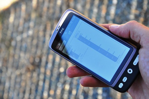
A new smartphone application, or “app,” is available as a free download for both iPhone and Android users to access soil survey information. The app, SoilWeb, combines online soil survey information with the GPS capabilities of smartphones.
The SoilWeb app is a portable version of the UC Davis California Soil Resource Lab’s Web-based interface to digital soil survey data from USDA’s Natural Resources Conservation Service (NRCS). Because the app provides soil survey information in a mobile form, it is particularly useful for those working in the field.
NRCS introduced the Web Soil Survey (WSS), an online tool for accessing soils information, a few years ago. This was a wonderful development for users of soils information—engineers, developers, farmers and many others—because WSS provides quick access to the most current data produced by the National Cooperative Soil Survey.
Until recently, a disadvantage of Web-based soil survey formats was that user access was limited to desktop computers with an internet connection. That’s one reason that NRCS soil scientist Dr. Dylan Beaudette, while still a graduate student at UC Davis, developed the SoilWeb app in collaboration with NRCS and the UC Davis California Soil Resource Lab.
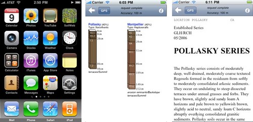
SoilWeb can retrieve a graphic summary of soil types in response to a user inquiry in the form of soil profile sketches. Each profile sketch shows soil horizons, often compared to a vertical ice cream sandwich made up of layers of soil. Soil names, locations and taxonomic categories are also shown.
Clicking on soil sketches sends the user to the corresponding Official Series Description, a user-friendly narrative of commonly used soil properties such as horizon depths, colors, texture and rock fragment content. Clicking on a soil name (listed above each sketch) provides the user with a more detailed description, including: physical and chemical properties, definitions and links to a variety of environmental databases.
This means that a farmer, rancher or even a backyard gardener could use a smartphone to gain an understanding of the soil type in the surrounding landscape. Soil health is a key factor in the success of plants—the type of soil determines what nutrients are needed, as well as how much water should be applied.
SoilWeb is useful even for users already familiar with NRCS’s Web Soil Survey, as it is much faster than pulling up soil survey information on a desktop or laptop computer.
Check out more conservation stories on the USDA blog.
Follow NRCS on Twitter.

