This post is part of the Science Tuesday feature series on the USDA blog. Check back each week as we showcase stories and news from the USDA's rich science and research portfolio.
By Mary Ann Rozum, National Program Leader, USDA National Institute of Food and Agriculture
As a national program leader at USDA’s National Institute of Food and Agriculture, a grant-making organization, I am normally on the front end of ensuring that scientific information makes its way onto the farm and into classrooms across the nation. However, last week I had the opportunity to get my hands dirty, so to speak, by participating in National Lab Day (NLD).
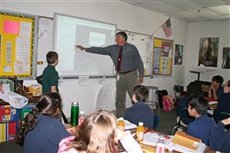
NLD is a nationwide initiative that matches volunteer students and scientific professionals with educators to bring discovery-based science experiences to students in grades K-12. The NLD website matched me with fifth-grade teacher Doug Schoemer at Flint Hill School in Fairfax County, Virginia to teach an earth science project on the Nile River and the history of food production and natural river cycles.
We taught an interactive watershed exhibit that demonstrated erosion and flooding and ways to manage agriculture production in ancient times as well as the present. In addition, we used Google Earth maps and had each student adopt a section of the Nile River and interpret aerial photos of agriculture fields, dams and cities today and plot points from their textbooks on the map.
In addition to teaching Mr. Schoemer’s class, I taught two additional fifth grade classes about the watershed demonstration and how river systems function, whether on the Nile, or the local Potomac or the Mississippi Rivers, and the importance of protecting watersheds and water supplies. The students asked a lot of good questions on how we get our city water supplies and how to protect their own home wells and ponds from pollution. The students led a virtual tour of the Nile River with Google Earth maps, and have continued to use mapping to study more current issues such as the oil spill in the Gulf of Mexico.
Mr. Schoemer and I are planning more ways to use the watershed exhibit in the classroom next year and new ways to apply mapping to other classroom projects. In fact, I enjoyed the experience so much that I plan to follow up with another school with a schoolyard garden. NLD is a great way to not only get to know the schools in my local community but to also share my passion and expertise with the next generation of future scientists.


